Hudson's Bay Company (1849) Heritage Trail


TRAIL STATUS UPDATE (last edited June 12, 2026)
Attention HBC trail users: Peers Creek to Manson’s Ridge is a mess and at this time we are advising avoiding this section of trail. Our crew is working hard but it will be a while before we can get it all cleared.
The bad news: hundreds of trees came down in the Peers Creek valley this winter and spring. The start of the trail is a huge mess of downed trees, and also about 600 metres east of Manson’s Camp towards Manson’s Ridge and for that we need to hire a faller to help clear. The FSR still has the big danger zone caused by the 2021 atmospheric river washing away a large section so is quite dangerous to cross, meaning both road and trail access are treacherous and we recommend avoiding this section all together for the time being.
The good news: All the big beautiful bridges we built over the last couple of years survived! While this section has a lot of really large downed trees, we’re hoping to have it all cleared by mid summer but we can’t guarantee an exact date as it’s a big job and we have lots of trails to work on. Also, Sowaqua FSR is supposed to be repaired and open this month sometime so you could potentially start/end there instead for a western access point if you have access to 4wd.
Stay tuned to the Hudson's Bay Company (HBC) Heritage Brigade Trail info Facebook group for the most current updates.
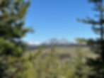
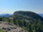
The HBC (1849) Heritage Trail is a 75 km long trail that traverses the Cascade Mountains between Hope and Tulameen in beautiful British Columbia. Gaining a cumulative 3,922 metres of elevation over rough and rugged terrain, this challenging trail is often completed in smaller sections as day hikes or overnights, with some others taking it on as a 5-8 day backpacking trip.
The trail, including all campsites, are free to use and do not require a reservation nor a permit. Please, however, if you use the trail, consider making a donation to Hope Mountain Centre to support all the work that gets put into maintaining it every year.
Looking for updates on trail status? Join our HBC Heritage Trail Facebook Group for trail reports and other HBC Trail info from Hope Mountain Centre and other trail users.

HBC Map & Guide Book
Plan your trip and navigate this trail by purchasing a waterproof, topographic map, and/or a guidebook that we published about the HBC Trail. You can click below to purchase from our online store, or find them in local shops in Hope like Baker's Books, Hope Outdoors, and the Hope Visitor Centre, and at Mt. Waddington's Outdoors in Chilliwack. All proceeds support our annual maintenance of this trail. Prices include shipping!
HBC Trail Merch


NAVIGATION APPS
Prefer using digital maps and navigation on your phone? Download the HBC trail map for offline access on the Avenza app.
Trail Info
Trailhead and Road Access Locations:
Peers Creek: https://maps.app.goo.gl/p9QcJiVg6QCcGPiQ7
Sowaqua: https://maps.app.goo.gl/kiBqUwddp6gP7PJB7
Jacobsen Lake: https://maps.app.goo.gl/6aYGUtwqYW3T58V47
Tulameen: https://maps.app.goo.gl/CeanmtsA5kSnL6Pa7
One-Way Trip Trail Distance in KM: 75
Elevation Gain in M: 3,922
Highest Point in M: 1,860
Dogs Allowed: Yes (on leash)
4 X 4 Needed: Not to access Peers Creek, Jacobsen Lake, nor Tulameen. 4x4 is required to enter via Sowaqua FSR.
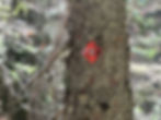
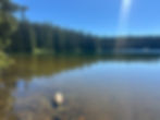
Regular restoration and maintenance work makes it possible to travel this historic route. The trail offers hikers and horseback riders stunning mountain scenery, rolling wildflower meadows, and clear blue tarns. You can still find 160-year-old blazes on the trees and thousands of HBC pack animals have left a visible impression upon the land.
Please respect the trail’s non-motorized status and “Heritage Trail” designation.
Heritage Designation
The HBC (1849) Heritage Trail is legally protected by the Province of British Columbia. A 200-metre-wide buffer zone is centered on the trail (100 metres on either side) protecting the 50-kilometre section from Peers Creek FSR to the Whatcom Trail Junction. Resource extraction is not allowed within the 200-metre buffer.
Come Prepared!
The HBC Trail crosses rugged wilderness. Make sure you follow BC AdventureSmart's "Three Ts" of Trip Planning, Training, and Taking Essentials.
Some key tips:
* It is best to travel the trail in mid summer to early fall when snowpack is largely melted and streams are running low.
* The trail route is cleared and marked, but a detailed topographic map and compass or offline GPS map and spare batteries/external power pack and charging cord are recommended.
* There are no potable water sources on the trail so bring a water purification system for refills on the trail
* Prepare for changing mountain weather. It often snows on the high mountain passes in the middle of summer!
* Make sure you tell someone your route and when you plan to return.
Trail Distances Between Camps
Peers Creek trailhead to Manson’s Camp: 7 km
Manson’s Camp to Colville Camp: 5 km
Colville Camp to Sowaqua Camp: 7.75 km
Sowaqua Camp to Chevreuil (Deer) Camp: 3.75 km
Chevreuil (Deer) Camp to Conglomerate Flats: 3 km
Conglomerate Flats to Jacobsen Lake: 2.5 km
Jacobsen Lake to Horseguard Camp: 11.5 km
Horseguard Camp to Blackeye's Camp: 6.2 km
Blackeye's Camp to Lodestone Lake Camp: 9.8 km
Lodestone Lake Camp to Olivine Camp: 9.5 km
Olivine Camp to Tulameen trailhead: 9km
Total trail distance across the Cascades from Peers Creek to Otter Lake: 75 km
Guided Trips
Hope Mountain Centre offers an Intro to Women's Backpacking course each summer that typically takes place on a different section of the HBC trail. Learn more here and by signing up for our email list.
Occasionally Ascent Fraser Valley Mountain Guides also offers a guided trip along this trail.
Trailhead Parking
Not everyone feels comfortable leaving vehicles overnight at trailheads. While at the time of writing there are no shuttle services offered, the Peers Creek trailhead in Hope is only a 15 min (15km) drive away. You could park in town and hire a taxi (Hope Taxi (604) 869-5501) or ask someone in town for a lift. The town of Tulameen is a 5 minute (3.4km) drive from the Tulameen trailhead.
Leave No Trace
* Pack out everything you pack in
* Cook with a portable stove and avoid using campfires.
* Protect bears by never leaving human food scraps behind.
* Stay on the trail and don’t trample sensitive meadows.
* Use outhouses when possible, or bury human waste in topsoil at least 100 m from any water source.
Learn more here.
History
Originally a First Nations route for hunting and trade, this trail played a key role in British Columbia’s early development.
BC’s First Link Between Coast and Interior
Completed in 1849, the HBC Trail was built by the Hudson’s Bay Company with the help of local First Nations. They built the trail to link the Fraser River at Fort Hope with Fort Kamloops and other important fur forts farther north to Stuart Lake. For more than a decade, the HBC’s fur empire in Western North America depended on this trail.
Hundreds of pack animals and men crossed the Cascade Mountains on this trail from 1849 to 1860.
Hudson’s Bay Company “Brigades” were essential for getting valuable furs to world markets, and for re-supplying HBC Forts in the BC Interior and far North. BC’s early economy developed around this trail and the fur industry it supported.
Original flag of the Hudson’s Bay Company (HBC). Established in 1670, the HBC is the oldest private corporation in North America and one of the oldest in the world.
Ancient Pathways
The HBC Trail falls within the traditional territory of three First Nations. The Stó:lo, Nlaka'pamux (Thompson), and Similkameen used trails over the Cascade Mountains to gather plants, hunt, and trade with each other.
Coastal and Interior groups each had resources the other needed. Coastal
villages traded dried salmon, sockeye oil, rare shells, and cedar products.
Interior groups traded valuable plants, including tobacco, sage, and Indian hemp — a critical plant for making fishing nets, rope, and clothing.
When Hudson’s Bay Company explorers arrived in search of a new fur trade route over the Cascades, they hired First Nations guides to lead them. A respected Similkameen chief named “Blackeye” showed his hunting route over the Tulameen Plateau to A.C. Anderson in 1846, and this became the inspiration for the HBC fur brigade trail of 1849.
There was much collaboration between First Nations and European fur traders in the years that followed, and in general, this early relationship was beneficial to both.
A network of mountain trails have enabled First Nations to gather plants and hunt for centuries.
Women used "tumpline baskets" like this to carry berries, bulbs, and medicinal plants from local mountains back to their villages.
First Nations horse packers in the 1890’s. Stó:lo, Nlaka'pamux, and Similkameen members worked for the Hudson's Bay Company along the trail as trappers, cooks, packers, guides, and postal carriers. Many First Nations also traded directly with HBC forts, gaining access to valuable goods such as hunting rifles, cooking pots, and steel tools.
Fur & Politics
HBC Fort Hope
Fort Hope was established by the Hudson’s Bay Company in 1848, beside the Stó:lo village of Ts’qó:ls. The new fort would function as the HBC’s key transfer point between mountain fur trails and Fraser River boats. Its name reflected the company’s desperation to replace trade routes lost to the Americans in 1846. This new fort was their best hope.
The original Hudson’s Bay Company Store (right) on Water Street in Hope.
The “Brigade Trail” of 1849
In the summer of 1848, HBC surveyor Henry Peers and a company of 10 men built the trading post at Fort Hope while also frantically building the "Brigade Trail" from Fort Hope to Fort Kamloops. The trail had to be ready by the spring of 1849, to enable HBC furs from the BC Interior to reach the Coast. The previous year had been a disaster when 70 packhorses perished while trying to negotiate the deadly Fraser Canyon.
Peers’ trail was a success, and for the next decade, brigades of up to 400 cattle, pack horses, and men regularly pounded the rugged trail between Otter Lake and Hope.
HBC brigades typically crossed these mountains in late summer and fall when snowpack had melted and water levels were low, allowing for easier river crossings.
Death on the Trail
Horses of the HBC Brigades had to cross mountains and rivers with heavy loads. Each horse carried two 90-lb "pieces" containing everything from fur and gold to mail and tools. Many pack animals died from extreme weather, injury, and physical stress. In his 1859 account, Lieutenant Palmer of the Royal Engineers describes his horse becoming spooked by the bleached bones of horses that had died by the dozens during an autumn snow storm a few years before.
Life was hard on the men too. Some died on the trail, and the average life expectancy of an HBC employee was 45 years. Most famously, an HBC Chief Trader named Paul Fraser was killed at Campement du Chevreuil (Deer Camp) when a tree fell on his tent. The tree had been felled by his own men. Fraser was widely despised, and many historians have speculated that it was no accident.
Decline of the HBC Trail
The Brigade Trail declined in use when better trails were constructed during the 1860’s. By then, gold fever had eclipsed the fur trade, and routes such as the Dewdney Trail and the Cariboo Wagon Road offered better access to the Interior. However, the HBC Trail continued to be used for several decades by First Nations, trappers, miners, and hunters.
Heritage Context Study
The Sto:lo Research and Resource Management Centre, in collaboration with the Upper Similkameen Indian Band, have completed a detailed study of the trail corridor, including First Nations history, European history, and natural history. You can read it here. The report makes recommendations for the long-term management of the trail and its resources, as required by the BC Heritage Branch.


a.jpg)


HBC Merch
Love this trail? Purchase an HBC Trail activewear t-shirt or tank top! You can click below to purchase from our online store. All proceeds support our annual maintenance of this trail.

Volunteers
Special thanks must go to the many volunteers who have given hundreds of hours of hard work to improving the HBC Trail for public enjoyment. In particular, Penticton resident Harley Hatfield deserves special recognition for the work he did during the 1960’s, 70’s, and 80’s to relocate the trail and have it protected from disturbance. Many members of the Okanagan-Similkameen Historical Society have worked on the trail, as well as members of the Okanagan Historical Society. In more recent years, trail enthusiast Kelley Cook and the Backcountry Horsemen of BC have restored eastern sections from Horseguard Camp to Palmer’s Pond and approached Hope Mountain Centre to help restore the western sections (Palmer’s Pond to Peers Creek). Many Hope residents and citizens from across the Lower Mainland and beyond have joined with Hope Mountain Centre to complete the work begun by Harley Hatfield in the 1960’s.
The HBC Trail has captured the imaginations of many people, attracting a team of passionate stewards who will take care of this historic route for years to come.
If you would like to volunteer in this trail, please email us a completed volunteer registration form to info@hopemountain.org and sign up for our enews.
Trail Work
Other Trails Nearby
Trail Reports
Make sure to join our HBC Heritage Trail Facebook Group for updates on this trail from Hope Mountain Centre and other trail users.
Or feel free to leave a comment below with trail reports so other users can learn about current conditions.
To ask us a question or to report an issue with the trail, please email our trails team kpearce@hopemountain.org or info@hopemountain.org as we do not monitor this comment section regularly.
My previous link is not working but I did this trail from Sept 3-7, 2024 and wrote a detailed trail guide about it. Check it out here: https://kaitlinhikes.wixsite.com/kaitlinhikes/post/hbc-heritage-trail
I did this trail from Sept 3-7, 2024 and wrote a trail guide to it. Check it out here: https://www.kaitlinhikes.com/post/hbc-heritage-trail
Hello good morning from lytton I ran into fellow believe name was Nate but talked about about what I done and thought you had great program and love learn more about it
Hello! I was told there was a need to register to join the HBC hike on June 1 but I can't find where to register. Let me know if you can point me in the right direction?