Serpent's Back


Trail Stats
Trailhead Location: https://maps.app.goo.gl/hGJoHv3mj5RMjZHq8
Round Trip Trail Distance in KM: 5.5
Elevation Gain in M: 435
Highest Point in M: 440
Dogs Allowed: Yes (on leash)
4 X 4 Needed: No
Connecting Trails: Thunderbird Trail (coming soon!)
Map & Elevation Profile


Trail Access
The trailhead and parking lot are at the end of a short gravel road approximately 1.5km down Silver Skagit Road. Look for the sign on the west side of Silver Skagit Road for the turnoff.
Here is the google map for the parking lot: https://maps.app.goo.gl/hGJoHv3mj5RMjZHq8

Opened in 2020, this trail has quickly become one of the most popular hiking trails in the Hope area.
Located on crown and District of Hope municipal land, this intermediate level hiking trail is 5.5 km round trip with a cumulative elevation gain of 435 metres. The high point is 440 metres, meaning it is snow-free for most of the year.
Dogs are permitted on the trail, but please be responsible to ensure they are picked up after and do not wander off the trail to disturb wildlife or the surrounding habitat.
The trail is located in Silver Creek, a neighbourhood just west of Hope town centre, in the Skagit Range of the Cascade Mountains.
There is a mountain biking trail network called The Core in this area as well.
There are no garbage cans or toilets at the trailhead, nor along the trail. Please practice Leave No Trace principles and pack out anything you pack in.
Trail Description
From the trailhead, follow the trail for just a few minutes and off to the right down a small path you will find a very long rope swing.
Pass this turnoff and you will find another trail sign after just a couple minutes. The trail undulates with some very steep ups and downs, broken up with a couple of nice flat sections. There are benches along the way for a nice rest.
It is mostly a natural trail, with a few sections of stairs and bridges to aid navigation. Please ensure you do not braid the trail (do no shortcut off the established trail) as this erodes the slope.
The first viewpoint is of Hope Mountain, followed by the viewpoint over the Silver Creek neighbourhood. After that you will reach the Stone Garden.
There is only one major junction, giving you a choice to go left or right around a loop close to the top. Going left you will arrive at the West Lookout first, before arriving at the summit. Either way you go, doing the loop or as an out-an-back, it's approximately the same distance as the summit view is halfway around the loop. Arriving from the west, you first see a view looking east over Silver Creek and the town of Hope to the far left. A few more steps and you’re looking south down over Silver Creek towards Washington State. Many peaks viewable from here: Wells Peak, Mount Grant, Eaton Peak, Silver Peak, Isolillock Peak, and more.
The trail features seasonal waterfalls, abundant flora like old-growth Western red cedar and Douglas fir trees, giant granite boulders (likely glacial erratics left behind by the last ice age), and a tilted granite slab. Note that rock climbing is not permitted in the Stone Garden due to the historical and cultural significance of the area.
Note there is some cell phone reception on parts of this trail but it's always best to download any electronic maps you plan on using beforehand such as Gaia GPS or AllTrails.
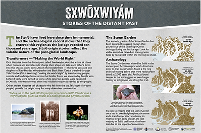
First Nations History
The Stó:lō Research and Resource Management Centre conducted an archaeological assessment of the proposed trail area before building, which indicates the area was originally traversed by Stó:lō hunters and travellers, and used as a safety lookout to help guard the villages along the river dating back over 2900 years.
The trail previously had the name Dragon's Back including the Halq’eméylem name of Kw'okw'echíwel Stl'áleqem, as from afar this mountainous area is reminiscent of a sleeping dragon. However it was discussed that dragons are mythical creatures and not stl'áleqem. Local placename expert Sonny McHalsie shared that dragons are not part of Sto:lo language and culture so thanks to the help from him and other local First Nations individuals the name was changed to Serpent's Back or A:lhqeyétsel in Halq’eméylem. Signage was updated in 2024.
Please visit the trail where you can see the interpretive signage we've placed with more First Nations history and information. Signs were installed in summer 2025 at various stops along the trail. A copy of the signs are below.


We would like to recognize and thank the following people who we consulted with during the research, writing, and design of these signs:
-
Lisa Dojack (SRRMC archaeologist)
-
Chawathil Chief Norm Florence and Council
-
Shxw'Ow'Hamel Si:yam Council
-
Elizabeth Phillips (Halq'eméylem speaker)
-
Dianna Kay (Linguist, Seabird Island First Nation)
-
Vanessa Hope (HMCOL Board Member, Yale First Nation)
-
Elsie Kipp (HMCOL Board Member, Yale First Nation)
-
Sonny McHalsie (Placename Historian)
-
Carrielynn Victor (Indigenous Artist and Knowledge Keeper)
-
Dave Schaepe (Head of SRRMC Archaeology)
-
Shane John (Chawathil Knowledge Keeper)
-
Bonnie Graham (Indigenous Artist)
You can also see the info guide from the Indigenous History Hike we held here in 2022.
Trail Work
Hope Mountain Centre began construction on the trail in 2019, opening to the public the following year in 2020. Our trail team continues to maintain and enhance the trail each year thanks to funding support from the District of Hope, Cascade Lower Canyon Community Forest, and others. See a full list of our partners here.


Other Trails Nearby
Trail Reports
Feel free to leave a comment below with trail reports so other users can learn about current conditions.
To ask us a question or to report an issue with the trail, please email our trails team kpearce@hopemountain.org or info@hopemountain.org as we do not monitor this comment section regularly. Alternatively, feel free to post in our "Friends of Hope & Area Trails" Facebook group to let our team know, as well as learn about all the latest work happening on the trails we manage.
Kudos to the volunteers that developed this wonderful trail. It is so well maintained and with ropes to aid, stairs made, and benches - all fabulous adds. Description in this site is dead on. Minutes from the highway so easy access. Beautiful forests and views!
This trail was intense for me as a beginner but I did it and I felt so proud. Gorgeous forest and views. Can't wait to do it again!
Wow climb today poring rain but so impressive take you 64 year old truck driver from Quebec thanks wonderful hike very satisfying